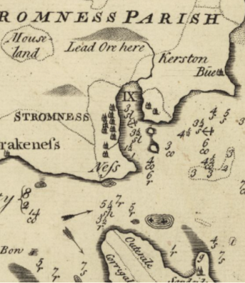
Look at the depth markings – they are pretty much identical for the MacKenzie map but deeper than the Collins and Moll. Also, the shading (for shallows, I guess) off the northeast tip of Graemsay is identical.
So at a guess, your new old map is either drawn from the Murdoch map or is something that Murdoch used – i.e. c. 1750 maybe a few years earlier?
Pictured above are two of the Orcadians who are to be included in our tie-in exhibition for the 2010 Orkney International Science Festival. We are hoping to have it up by Wednesday afternoon or Thursday morning but anyone who could see the teetering piles of documents strewn haphazardly around the room would guess at an inauguration date closer to September 2020.
It will be fine.
Other events of today have included:
Eating a slice of excellent iced gingerbread which was baked by an unknown member of staff.
Finding old 70s photographs of older staff members and asking them how they got their hair to do that.
Looking for the same missing estate map twice, emptying out the entire map drawer each time.
Taking it in turns to wrap our arms around the ankles of our departing staff member, allowing him to drag us around in his wake.
Watching the Bookbug toddler group to take turns in the lift. (Ours is the only publicly accessible lift in Orkney. Consequently it's quite a hit with the kids. I'm thinking of charging for gos on it.)
It's Friday and I'm tired. It's time for some invigorating East Kilbridey pop:
Although I have used the National Library of Scotland's website before, I had not used this feature. The selection of historical maps there is excellent.
Although not related, here is an interesting map. It is a plan of the Orkney Islands published by John Thomson and Co., Edinburgh showing the boundaries of the Earldom and the Bishopric (reference number D7/1/1).
2 things for your perusal this gloomy Monday morning.
#1: A letter which mentions biscuits.
#2: a man on a pig.
Biscuit letter reference D2/9/15 (Miscellaneous Manson family correspondence and vouchers mainly relating to William Manson, wright, Kirkwall and his business and his son Captain William Manson's business and activities in Jamaica and Georgia.)
Man on pig reference D8/E/27 [G3] (Map ofSebay, Tankerness Dundas Estate. William Aberdeen c. 1769.)